
Mine Geologist
From face mapping to ore control in a single flow with data governed from capture to decision.
✓ Geological mapping & drillhole logging
✓ Face / bench modelling in‑context
✓ Ore control & reconciliation feedback loop
✓ MineTrust governed datasets

Includes: MineTrust, Studio Mapper, DH Logger, Studio Geo, Ore Controller.
Speak with our experts
Not sure where to start? Get expert advice and develop an action plan by talking with our solutions specialists.

OP Resource Geologist
Modelling and estimation that prioritise a true reflection of the subsurface, supported by validation and traceability for open-pit reserve preparation.
✓ Implicit modelling & estimation
✓ Variography, QA/QC, validation & traceability
✓ Reserve preparation for open pit
✓ MineTrust governed datasets
Includes: MineTrust, Studio RM, Studio Geo, Supervisor, Isatis.neo, Isatis.py, Maxipit.
Speak with our experts
Not sure where to start? Get expert advice and develop an action plan by talking with our solutions specialists.

UG Resource Geologist
Modelling and estimation that prioritise a true reflection of the subsurface, supported by validation and traceability for mineable stope optimisation.
✓ Implicit modelling & estimation
✓ Variography, QA/QC, validation & traceability
✓ Mineable stope optimisation
✓ MineTrust governed datasets
Includes: MineTrust, Studio RM, Studio Geo, Supervisor, Isatis.neo, Isatis.py, MSO.
Speak with our experts
Not sure where to start? Get expert advice and develop an action plan by talking with our solutions specialists.
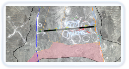
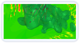
Use the latest mapping technologies with integrated solutions for mine mapping, and structural and geotechnical feature capture. Choose your capture method with advanced photogrammetry software, 2-D photography, and integrations with third party LiDAR scanning tools.
 Studio Mapper Studio Mapper |  Sirovision Sirovision |
 Pix Pro Pix Pro |

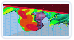
Gain a thorough understanding of mineralisation, variability, and uncertainty so your models remain a true reflection of the subsurface and support confident classification decisions.
 Supervisor Supervisor |  Studio RM Studio RM |
 Isatis.neo Isatis.neo |  Isatis.py Isatis.py |
 Studio Geo Studio Geo |  MineScape RM MineScape RM |

Use the market leading software for the creation and evaluation of geological models of stratigraphic deposits. Designed to deal with complex faulting and intricate stratigraphic relationships, models can easily be updated and shared as new data is collected.
| MineScape Geology |

Minimise ore loss and optimise your production to plan with our intelligent ore control solution. Bring standardisation and integration of your reserve estimation processes into the mine production processes to unlock financial benefits amounting to tens of millions of dollars a year.
 Ore Controller Ore Controller |

Simplify field data capture with mobile and tablet devices, allowing geologists to capture, store, and share data efficiently. With flexible workflows and seamless connectivity, it streamlines the process from data capture to updated reserves, boosting productivity for mine and field geologists.

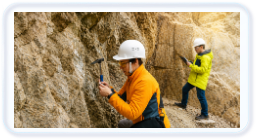
Capture hassle-free and safe geological and geotechnical images, reducing interaction and disruptions to production. Deliver cost-efficient mapping and enhanced safety by enabling remote data collection with easy-to-use tools requiring minimal training.

Capture and process high-resolution imagery from the air, providing early detection of non-compliance to plan or slope stability risks. Leverage the full value of a digital twin for planning and communication.

Get the most out of costly drilling data with our tailored solutions for resource estimation professionals with intuitive workflows and innovative tools. Leave no stone unturned and no insight uncaptured, all bundled within user-friendly interfaces for confident decision-making.

No deposit is too complex for our industry-leading toolkit of advanced geostatistical workflows. Exploit the power of complex techniques, developed over decades, and presented as accessible, intuitive workflows that are easy to understand and use.

An industry standard for geological modelling and resource evaluation, our solutions help teams build block models that are a true reflection of the subsurface. Validation and traceability support confident resource and reserve modelling, with automation to streamline workflows and reduce errors.

Our integrated suite provides a unified solution for geological data management, stratigraphic modelling, and efficient block modelling. By aligning these capabilities with other site functions, mining operations can achieve enhanced operational efficiency and maximise the value of their resources.

Our intelligent ore control system ensures optimal material allocation, maximising the value of each load. With customisable, pre-defined workflows and a user-friendly multi-user platform, our tools enhance efficiency by guiding users through their tasks. Deliver seamless collaboration under standardised governance to ensure consistency across all ore control practices.

Set a discovery meeting with us to map out the situation, and determine the key variables and your desired outcome.

We will develop a meaningful demonstration of a contextually similar project example in the software, and present this to you along with our commercial proposal and relevant supporting materials.

If you purchase the software, we will design a complete implementation plan for your specific situation.

Our support experts will be available to help whenever you need it after you are up and running.

Set a discovery meeting with us to map out the situation, and determine the key variables and your desired outcome.
We will develop a meaningful demonstration of a contextually similar project example in the software, and present this to you along with our commercial proposal and relevant supporting materials.
If you purchase the software, we will design a complete implementation plan for your specific situation.
Our support experts will be available to help whenever you need it after you are up and running.


Rafael Souza
Technical Manager


